İbrahim Canbulat, M. Arch.
Safranbolu is recorded as site # 614 and date 1994 in the World Heritage List prepared by the UNESCO World Heritage Committee. Safranbolu was inscribed in the World Heritage List as “Cultural Heritage” as per criteria (ii), (iv) and (v). Within this context Safranbolu is listed for
ii) The key role Safranbolu has had in the caravan trade over a long span of time, it has enjoyed prosperity and as a result has set the standards of general and local architecture that have affected urban development in a large area of the Ottoman Empire,
iv) The caravan trade that has been the basic trade link between the East and Europe for centuries and as a result, cities with characteristic features were established all along this caravan route. These cities lost their initial raison d’être with the coming of the railroads in the 19th century and many turned to other economic resources. However, Safranbolu was not affected by this and therefore preserved its original state and buildings to a great extend.
v) The end of the caravan trade had devastating effects on Safranbolu. The proximity of the Karabük Iron and Steel Factories ascribed a new socio-economic role to Safranbolu. However, it is still affected by external factors. Therefore, continuous efforts must be made to preserve this traditional settlement (UNESCO 2009, 215–240).
Safranbolu is a city where people continue to live. Therefore, it displays a widely more complex structure than the other 10 UNESCO World Heritage areas in Turkey. The different phases that Safranbolu went through will be dealt with in three different sections in this paper. These are:
The Formation of Safranbolu (Prior to the 1930s),
The Preservation Efforts in Safranbolu (1930s — 1990s), and
The Threats Confronted by Safranbolu as a “Touristic – Historic” City (After the 1990s).
It would be incorrect to consider the impressive physical structure of Safranbolu as solely Ottoman. Safranbolu is known to have a cultural heritage that dates of at least 7500 years. While Çarşı and Bağlar display the Seljuk – Ottoman continuity, Kıranköy displays Roman-Byzantine-Ottoman continuity. The structures that we refer to as Ottoman konaks (mansions) today are heritage structures and construction systems dating of the Hittites. We observe that the master builders and workers go on using the traditions and skills of the Hittites, Romans, Byzantines and Ottomans. On the other hand, the well preserved urban fabric of Safranbolu gives us important information regarding the family and social life of both the Muslim and Greek-Orthodox Ottomans.
Being located at the eastern tip of the Ottoman lands, though temporary, Safranbolu was a residence area for the “yörüks” (Turkish nomads) continuously arriving from Asia. The population required by the centuries long move of the Ottomans towards the West shifted from this area as new territories were conquered. In the past, Safranbolu was administered by two different local governors; the Qadi of Medine-i Taraklı Borlu and the Qadi of Yörükan-ı Taraklı Borlu. Even today, this dual structure is still influential in Safranbolu and should be taken into consideration in order to understand the preservation processes in the city, from the shaping of the konaks of Safranbolu nobles who used the nomads as sharecroppers, to the new urban/rural life in the konaks when they were abandoned by the first owners and taken over by the nomads.
Following the 1930s Safranbolu has almost literally gone through the intellectual, professional and political processes regarding the history of urban preservation in the world. Therefore, in addition to being an important source for academic research, it also has the quality of being an example to similar urban preservation implementations. In this article, the different phases of the preservation process have been explained with detailed footnotes.
Even though the purpose of this article is to analyze Safranbolu as a UNESCO World Heritage City, time and again I have been obliged to go beyond this scope. In the sections regarding the names of Safranbolu and its history I observed discrepancies in various sources due to the fact that Dadybra was identified as Safranbolu only as late as the 1970s. Therefore, I was obliged to get to first degree sources and add some of my conclusions. As I will point out later, numerous new studies are being conducted regarding Ottoman cities and urban dwellers. Provided that it is not much out of context, I felt that first of all, it would be a good idea to examine issues such as the notables period, the guilds and the “proto-industrial cities” that emerged in Anatolia. The subject became more complicated in the case of Safranbolu houses. Although we have only a very few Ottoman houses dating prior to the 19th century, we are making abstractions and generalizations in broad lines — at times even extremely idealized — on the characteristics and typology of the Ottoman house based on konaks built in the 19th century. As I have stated below, the Safranbolu house that was a “hayat house” until the 18th century went through a significant change as a result of the changing socio-economic structure, the more liberal atmosphere and the unfamiliar inspirations that arrived over Istanbul as of the 18th century. At least, I felt the need to share the initial clues of the scientific research we are conducting on this subject. Using the rich cultural heritage of Safranbolu was what encouraged me in this.
Safranbolu has to be evaluated together with Karabük, to which it is presently attached administratively, in order to better understand present-day Safranbolu. Safranbolu’s socioeconomic structure of the 1930s was affected by the KDÇİ (Karabük Iron and Steel Enterprises), Turkey’s first heavy industry investment, and later, equally by its privatization in 1994. Even today, 20 years after the unplanned formation of privatization that is called “deindustrialization,” it continues to affect Safranbolu strongly.
Beginning with the 1990s, the Turkish Touring and Automobile Association purchased the Havuzlu Asmazlar Konak on Beybağı Street and after its restoration operated it as a hotel. Thus, Safranbolu emerged as a tourist destination and became acquainted with tourism. Although it is a pathological relationship, it is almost impossible to think of heritage areas independently from cultural tourism. In this context, a significant number of registered konaks in Safranbolu have been restored and started to operate as hotels in the past 20 years. Today, despite its 2,650-bed capacity, Safranbolu’s tourism sector has problems due to insufficient occupancy.
Today, the Çarşı, Kıranköy and Bağlar districts are very different situations from each other as a result of the different processes they underwent. However, the problems confronted by the Çarşı District are much more complicated than the others. Besides losing its economic and administrative centrality function on one hand, the Çarşı District is attempting to cope with the negativities brought by mass tourism and on the other, it has encountered physical as well as social disintegration as a result of the decline in the life standards of the working population living there.
1. The Formation of Safranbolu (Prior to the 1930s)
We know that the Hellenic Greeks (first millennium BC) called the region where Safranbolu is located Paphlagonia. According to Umar (2005), this name, which is not Hellenic Greek, is the name of the region where the Kaskas, one of the native peoples of Anatolia, lived. We obtain information about the Kaska people from the Hittite sources (second millennium BC). However, in The Iliad that was collected in the ninth-eight centuries BC, Homer mentions the Paphlagonians, when describing the Anatolian peoples who went to help Troy.
Pylæmenes, a Chief of giant might
From the Eneti for forest-mules renowned
1040
March’d with his Paphlagonians; dwellers they
In Sesamus and in Cytorus were,
And by the stream Parthenius; Cromna these
Sent forth, and those Ægialus on the lip
And margin of the land, and some, the heights
1045
Of Erythini, rugged and abrupt.
Its boundary with Bithynia on the West was defined by the Filyos River (in some sources the Bartın River), with Pontus on the East the Kızılırmak (also known as Halys) and its north boundary by the Black Sea. Its southern neighbors were Galatia and Phygia. Until Anatolia passed into the sovereignty of the Turks, the area was ruled by the Hittites, Dor (“Sea People”), Paphlagonians, Cimmerians, Lydians, Persians, Cappadocians, Hellenic Greeks, Pontians, Galatians, Bithynians, Romans and Byzantines, respectively. Although geographically the region presents excellent opportunities for life, it was hardly affected by the significant movements of destruction and carnage in Anatolia because there are no works of affluence and civilization.
The local historian Hulusi Yazıcıoğlu (Yazıcıoğlu & Al, 1982, 33-38) lists the names of Safranbolu throughout history as follows: Dadybra, Zalifre, Borglu, Burglu, Borgulu, Borlu, Taraklı- Borlu, Taraklı, Zağfiran-Borlu, Zağfiranbolu, Zağfiran-Benderli, Zağfiranbolu, Zafranbolu and Safranbolu. We owe the coherent Dadybra – Zalifre passage to Osman Turan. Osman Turan (Turan, 1971, 219) stated that the place called Dadybra in Byzantine sources was called Zalifre by the Seljuks and proved that the location of Dadybra, which was debated until recently, is Safranbolu.
There are 24 tumuli and 3 large mounds on the Safranbolu Eflani route. None of these have been excavated. Sources regarding the ancient history of Safranbolu and its environs are limited. Archaeological excavations to be carried out will enable correct chronicling.
Even though it was set forth in many books and articles that it was not an important settlement throughout history, it is known that money was minted by Dadybra in the second-third centuries AD (Ramsey, 1890, 193; Oaks, et al., 2001, 4: 43-44). Based on Byzantine historians, Cramer (Cramer, 1832, 1: 238) writes that Dadybra was a patriarch settlement. In the official registers of Rome, it was regularly stated as one of the 6 cities of Paphlagonia starting as of AD 325 (Ramsay, 1890, 196-197). Most important of all, it has always had the attribute of being a strategic point due to the fact that it is at the junction of the secondary caravan roads connecting Central Anatolia to the Black Sea ports.
The studies we conducted with members of METU and Bilkent University have clearly shown that the area that is referred to as Kıranköy nowadays and where Greek-Orthodox subjects lived until the 1920s was a citadel city with a grid plan. In fact, Cahen (Cahen, 2000, 61) wrote that during the reign of Manuel Komnenos boundary fortresses were constructed in the region where Dadybra was located. The water distribution and storage network system under the city is the best evidence of this fact. Unfortunately, no detailed information regarding Kıranköy could be provided because no urban archaeology studies have been conducted here.
I believe that the height called “Kale” (citadel) today was not what the Seljuks took after the siege of Dadybra that lasted for 4 months. As the vineyards of Kıranköy descended the eastern slopes all the way to Gümüş Stream, houses belonging to the Christian subjects were found at Gümüş Canyon and what is even more important the fact that Dışkale Street is located here, I conclude that it must have been a rather large settlement (Magoulias, 1984, 475-476), because it was continuously referred to as “Dadybra Town” when describing the conquest of Dadybra. The height called “Kale” today where the palace of the local administrator and the buildings used by a group of security forces were located must have been an inner citadel at that time.
In 1196, after a 4-month siege, Muhiddin Mesud Shah, the ruler of the Ankara Region and son of the Seljuk Sultan Kılıç Aslan II, took possession of Dadybra by making an agreement with the Byzantine Emperor Alexios III Angelos. We must assume that as was accustomed the Seljuks established a simple settlement that was half market and half check-point in front of the gate to the citadel. Today, calling the region immediately underneath the Citadel “Below the Citadel” is significant proof of this. It is rumored that the Old Mosque (Gazi Süleyman Mosque) to the south of the Citadel was transformed from a church. The proximity of the Citadel, Mosque and the Marketplace Below the Citadel, the three important elements creating a Seljukid City, is proof that the first Seljukid settlement was here. The Old Hammam that is unlike Ottoman hammams should also be added to these.
In his well-known Book of Travels, Ibni Batuta who spent a night in Safranbolu in 1334 wrote about Safranbolu saying, “A small town built on a hill. There is a trench at the foot of the hill. At the summit there is a citadel. We spent the night at a madrasa there.”
Today, there are no architectural works that can be ascribed specifically to the Seljuk period in Safranbolu. However, we must recognize that Safranbolu’s City structure comes from the Seljuks. It reflects characteristics of a typical Seljukid City, such as the housing region formed with dead-end streets and established on a slope, the lack of a structured street system and squares and industry settled at the point where water leaves the city.
After Byzantium, Safranbolu was governed by the Anatolian Seljuks, Ilkhanids, Çobanoğlus, Candaroğlus and Ottomans, respectively.
The records of the land registry made for taxes in 1530 shows that were only 16 shops at the Safranbolu Market place at the time. In the same context, it appears that the Gebran District, which is called Kıranköy today, is mentioned as a small settlement with 27 households. This data leads us to onsider that Safranbolu regressed up until the sixteenth century. Even the traces of leather tanning and the leather industry which would emerge in later periods were not found in the land registers.
We are indebted to Hüseyin Efendi (Cinci Hodja) for the most important development that changed the destiny of Safranbolu. Hüseyin Efendi who was a young student at the madrasa at that time solved Sultan İbrahim’s psychological problems thus helping him to have a prince. As a result, Hüseyin Efendi acquired great wealth within a short time thanks to the position and opportunities provided by the sultan. He used most of this wealth for investments he made in Safranbolu. The end of Hüseyin Efendi was as fast as his rise. Following the death of Sultan İbrahim, Hüseyin Efendi was assassinated and his fortune was distributed to the janissaries as accession to the throne gratuities on the occasion of Mehmed IV’s (the Hunter) ascension to the throne. Along with the charitable acts of Köprülü Mehmet Pasha, who had a mosque and a social complex built in Safranbolu approximately 10 years later, the present day rich fabric of the historical city of Safranbolu practically emerged in the 17th century. The new Safranbolu emerged as a typical Ottoman City lying beyond the Citadel in the canyon formed by the Akçasu stream at the east of the Citadel.
Safranbolu was a province of the Kastamonu Sanjak and in the 18th century, providing that the port duties of Inebolu are excluded from the evaluation, Safranbolu that had tax revenues even higher than Kastamonu became the largest economy of the Sanjak. Following The Celali Uprisings Safranbolu’s success in industry and trade should actually be attributed to a more liberal environment as for some time the Ottomans governed the economy through the local notables. We know that the most important element of the Safranbolu economy in the 18th century was the operation of the caravans. This brought Safranbolu material wealth as well as cultural wealth which was the result of intercultural relations. Cultural interaction was not limited to this and wealthy families came and settled in Safranbolu. Families such as the Araphacıs (Arabia), Kırımlıs and Asmazs (Kazan) were among such families.
Safranbolu’s second economic activity was leather processing and production of leather goods. We know that there were over 80 tanneries operating at the south of the city and that they produced high quality leather. Safranbolu’s industrial function was not limited to leather processing. It had artisanal shops spread over the city and working on a guild order basis and a, so to speak, production line where very high quality yemeni (light, flat-heeled shoes), saddlery, packsaddles and similar products were made. Moreover, meat processing also become an important source of livelihood as a by product related to the tanneries in Safranbolu that imported 5600 cattle and water buffalo (Faroqhi 1993, 273-278). In the 17th century, some problems were created because some of the red sheep herds that were sent from Anatolia to meet the requirements of Istanbul were sold and slaughtered on the way. Complaints were raised about the Borlu Qadi because of the diminishing number of sheep on the route of Kastamonu – Borlu (Safranbolu) – Gerede. There were also 25 cured spiced beef makers in Safranbolu at the beginning of the 20th century (Yazıcıoğlu & Al 1982, 73).
We also know that there was a developed weaving culture in Safranbolu (Yazıcıoğlu & Al 1982, 71-73). In 1923 there were 350 cloth weaving looms and 120 looms for making horse-cloths or feeding bags of goat hair in Safranbolu. However, in my research I could not find any structure except Mutab Kerhanesi (weaving factory) on the West façade of Cinci Han that manifest itself on the exterior space (Yazıcıoğlu, 2001, 99). Therefore, it should be assumed that looms were usually in the houses. In most of the houses where I conducted restoration work I found spindles, loom parts, shuttles, and in one particular case (Gökçüler Konak) a room where fabric was dyed and some fabric dyes. In addition to showing large amounts of cotton and cotton threat imports (72.500 Ottoman liras), statistics show that white cloth was also exported to Istanbul (21.000 Ottoman liras). Weaving did not reflect on the urban space but was evident only through numbers. Apparently, fabric dealers had contract manufacturing done in homes and Villages, collected the product and sold it in domestic and foreign markets. Twelve of the 20 merchants registered at the Safranbolu Chamber of Commerce were recorded as “fabric dealers”. In addition, there were 32 fabric dealers not registered at the Chamber of Commerce. Home production shows that women labour was part of the industrial production in Safranbolu.
The importance of the Safranbolu Marketplace can be better understood by stating that at the end of the 19th century while there was 1 shop per 16 persons in Kastamonu, the sanjak centre, this number was 1 shop per 8 persons in Safranbolu (Aktüre & Şenyapılı, 1976, 69). Moreover, stating that Safranbolu was the administrative and commercial center for a region of a population of approximately 50,000 presents a very accurate picture of the economic structure of Safranbolu. Hence, it is this material and cultural affluence that created the influential physical structure which has remained until the present-day. The section of the “1889 Kastamonu Yearbook” devoted to Sarfanbolu states that there were: “28 mosques and mesjids, 2 libraries, 12 madrases, 13 passenger inns, 170 Muslim and 3 non-Muslim primary schools, 2 churches, 24 large commercial buildings, 11 hammams, 945 shops, 40 watermills, 60 water mill powered saws, 84 tanneries, 1 grain traders inn, 1government office,1 telegram office, 1 army storehouse, an army recruiting office, 1arsenal, 5 saint tombs, 2 praying time muvakkithane (praying time keeper), 1 high school, 1 elementary school, 2 police stations, 1 namazgah (open-air mosque), 107 fountains, 1 bedesten (covered bazar) (Yazıcıoğlu 2001, 87). The existence of the Bedesten is proof to how developed the commercial function was in Safranbolu. The bedesten not only served the function of keeping valuable goods, at the same time, it also undertook the financing functions realized by banks today. However, Cinci Han was not a simple caravansary. The rooms on the upper story served as offices for merchants (Aktüre & Şenyapılı 1976). Moreover, it was stated that there were foreign merchants who engaged in interregional trade by hiring rooms at Cinci Han. In this context, Safranbolu was a “break-of-bulk point”.
Cerasi (1999, 101) wrote that the Turks created the first country residence (suburbanization) in the world. The Bağlar District, which was formed as a result of the nomadic lifestyle of the Turkomans, has a very striking fabric with the splendid summerhouses built in gardens filled with vineyards, kitchen gardens and fruit trees by the conscious use of abundant water sources.
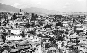
At the beginning of the 19th century, Safranbolu’s physical structuring reached the summit together with the Çarşı District where the Muslim population lived at the marketplace and its perimeter, the Kıranköy District where the Greek Orthodox subjects lived and the Bağlar District where they spent their summer months.
1.1. The Physical Structure of Safranbolu in the 18th Century
The Ottoman City overflowed the walls and formed at the edges of the Seljuk City. As I have stated above, after the Seljuk took over the city, they settled within the citadel and took control of the public space with the centre established Below the Citadel. The commercial structure of the Çarşı District was almost completed in the 17th century with the charities of Cinci Hoca first followed by those of Köprülü Mehmet Pasha. No doubt the Köprülü Mosque, New Hammam and Marketplace with the shops situated around and located in the center were fulfilling their social and commercial functions in such a way as to serve the rural population as well. The inns where nomads coming to the market would lodge and leave their animals were the other buildings serving the market. Another impressive feature of Safranbolu is that it solved the spatial problem created by its location within the canyon by placing the public buildings right at the very bottom of the canyon and at times even on the river itself. As for the Çarşı District, it was formed by single storey, single windowed shops that accommodate only two people and were brought together according to the guild order placed right around these buildings. The various vocational groups each located along a different street worked in a strict guild order. The street was named after the vocational group located on it and these names are still used to date: Göncüler Sokağı (Tanners Street), Kunduracılar Sokağı (Shoemakers Street), Kasaplar Sokağı, (Butchers Street) , etc. Each guild had its own coffee house where they performed their rituals, socialized and discussed matters related to their professions. Those at the Yemeniciler Arasta (Shoemakers Market) and Demirciler Çarşısı (Ironmongers Market) are still in good state and in service. Two physical heritages of Safranbolu’s two major economic functions have remained to date. One is the Cinci Han which is the most spectacular caravansary east of Istanbul and was commissioned by Cinci Hoca and the other is the tanneries area which is in extremely derelict condition and no longer functioning and causes distress rather than feelings of nostalgia.
The tanneries are positioned at the point where the Gümüş stream and the Akçasu come together and leave the city and use the water at that point. These features of the tanneries are one of the significant examples of an environment friendly physical structuring.
There are no squares in the Ottoman cities. The social areas in the Ottoman cities are only the mosques and their courtyards as a continuation of the Islamic tradition. There were also no official offices in the Ottoman City up until the 19th century and the officials used their own residences as their office. However, there were a significant number of buildings such as primary schools, madrases and dervish lodges providing public services. I have already mentioned that Safranbolu reached its socio-economic apex in the 18th century. It is especially necessary to mention the mosque and its income generating property, the clock-tower, the aqueduct that brought water to the city and the water network that Izzet Mehmet Pasha from Safranbolu, who later became the Grand Vizier, had built in the 18th century.
What is most important is that Safranbolu displays both urban and rural features? There are the Has fields on the higher flat areas above the canyons where Safranbolu is located. As a natural result of this, its half rural and half urban characteristic also reflected in the spatial structure of the houses.
The Ottoman City does not make use of the areas that are suitable for agriculture and generally locates on slopes. The dwelling fabric located on the slopes provided not only enough light and view to each residence but was also the right solution for the privacy issue. The use of the slope provides an easy solution to the clean and waste water systems. Ottoman cities that have an organic street fabric consisting of units bought together by neighborhood relations based on lineage. Although they were formed by families coming from different social status, until the 18th century, the appearance of the houses did not exteriorize this social difference. The dead-end street system with usually a fountain and generally a mesjid at the end created the possibility of providing the privacy of the neighboring units and their security when necessary in a sound manner. Due to the fact that neighboring units were connect to lineage, those of different religion, sect and ethic groups were living separately in different sections of the city and in villages that had close relations with the city (Cerasi 1999). I can give Kıranköy, Yazıköy and Yörük Köy which is a Bektashi village as an example to this. As with the Ottomans, in general, social class differences did not reflect on the physical aspect in pre-industrial communities. However, the Çeşme District known to have developed in the 18th century and situated on the eastern slope of the Citadel shows that Safranbolu’s urban fabric started to reflect social differences with the stately residences of the ruling class and the wealthy.
Due to the characteristics I have listed above, Safranbolu was an “industrial city” prior to industrialization as it had extensive external connections and logistical infrastructure. (Faroqhi 2003, 9-33) states that this is referred to as “protoindustrialization”. And the oldest known clock-tower of Anatolia commissioned by İzzet Mehmed Pasha is almost like its symbol.
1.2. Safranbolu Houses
Although their external façades are almost similar, it is necessary to group Safranbolu houses under three different categories. These are: the winter houses in the Çarşı (Marketplace) district, summerhouses in the Bağlar (Vineyards) district and the Greek Orthodox houses in the Kıranköy district. Three different house types with different characteristics have developed in three different settlements in Safranbolu as a result of the environmental and social differences. The Çarşı houses, whose majority belongs to the Muslim community, have in no way taken on commercial or artisanal functions. However, some houses such as the Beybağı (Asmazlar houses), Kaymakamlar (District Governors) House and the Pasha Konak were built as multi-functional residences comprising spaces required by the ruling class. It is believed that the few houses with shops or workshops on their ground floors at the Çarşı district today once belonged to the Greek-Orthodox citizens. As to Kıranköy, where the Greek Orthodox citizens lived, there is a shop or a workshop on the ground floors of almost all houses. In addition to this difference that can be perceived at a first glance, there are other distinct differences between the houses of the Muslims and the Greek Orthodox. There are spaces for winemaking and storing, ovens and prayer nooks at the Greek-Orthodox houses. Another characteristic is that while there is a passage only to the storage room, if any, from the rooms located around the “hayat” (ground floor living area) or the “sofa” (hall) in the Muslim houses, suite of rooms are common in the Greek-Orthodox houses. The most important characteristic of the Bağlar houses is their dimensions that are so large that they sometimes force the structure. The harmony between these houses and their well-watered gardens and the half-open shaded spaces that enrich life by carrying the heart-warming summer softness inside the houses are important characteristics. Rural characteristics are more prominent in the Bağlar houses. While the preparation of products from the meadows, fields, vineyards and orchards for the winter is carried out collectively, new spatial arrangements, in addition to the ones in the winter houses, necessary for especially the furnace required for these functions are seen.
The houses in Çarşı are located on the slopes of the canyons. As the barren soil of the canyons is not suitable for growing plants, the soil we see today was carried by camels and oxcarts and filled into the retaining walls. The vineries and orchards in the gardens of Çarşı make it look green in spite of its congested urban fabric. When the lots are analyzed today, it is seen that small lots of single houses are formed inside large lots due to the requirements of the gradually growing families or economic reasons. This is an indication that Çarşı was ingrowing as it gradually became congested.
The houses are built on rubble stonewalls adapted to the slope. Generally, the Ottoman houses place one façade on the street regardless of the size of the lot. It limits the relationship with the street on the ground floor except for a double wing door big enough for a loaded horse to go through. So much so that, walls on the street side continue as high garden walls and provide full privacy. The geometry of the ground floor does not only use the slope of the canyon as data but also accepts the non-orthogonal geometry created by the organic street fabric as it is. On the other hand, a three-dimensional relationship is established with the street through the çıkmas (consoles) and windows and thus, the ideal plan is achieved. The Safranbolu house is oriented to maximize the benefit from the sun and the view. Generally, wet area consoles that house the hela (toilet) and the abdestlik (ablution area) are located on the North. Therefore, these facades where the kubur (toilet hole) is placed below the wet-area consoles can be placed on the East or west as well, taking into account the direction of the slope of the canyon as well as the location of the neighboring houses. Until the 18th century Safranbolu can be considered as a settlement of as mud filled wooden frame houses over rubble stone walls placed on the slope of the canyon. At this point, we must imagine the Safranbolu house as a building with the “tahtani” (ground floor) and the “fevkani” (upper floor). The “ahır” (barn) or the “hazine” (store room) in the houses of the rich and the “taşlık” (hall with stone floor), where various material used for heating, mainly wood is stored, is located on the ground floor. The upper floor has two or three rooms located around a south facing “çardak” (pergola). One of these rooms is used as the “aşevi” (kitchen). The Safranbolu house with these characteristics is an exact “hayat house”. In Safranbolu, only the Mektepçiler House (Canbulat 2006) is dated definitely to the 18th century. All the other houses are known as 19th century buildings. Therefore, the Mektepçiler House is a good example of the above mentioned 18th century house.
There were no three-story buildings on the Ottoman lands until the 18th century. Following the 1858 Land Code, private ownership was accepted and the magnificent physical structure emerged due to the relatively liberal environment and its consequence that showing wealth should no more be feared. So much so that even the former dimensional limitations on the houses of the non-Muslims were lifted and grand residences competing with Muslim houses were built in Kıranköy. In the 18th century, one more floor was added on top of the fevkani that had permanent rooms around the hayat. According to the trends of the period and under the Western influence, almost all of the second floors comprise of rooms around an “orta sofa” (central hall). These plans called “orta sofalı” (with central halls) are the result of the baroque inspiration coming from Istanbul. The inspiration did not stop there. Neo-gothic (Victorian) wooden arched windows were fitted to the divans or the “şahnişins” (bay windows).
The most important characteristic of the Safranbolu houses is that they are created by “vernacular” architecture (architecture without architects) and they are entirely made of local materials. Vernacular architecture has continued to use old buildings’ elements within the context of a rigorous economy. What we today see as Safranbolu houses is a very valuable architectural heritage created by a practice of 3000 years.
I have already mentioned that Safranbolu houses are almost always built on a ground floor with rubble walls due to the slope of the canyon. Although these walls are constructed with clay mortar, little stone pieces called “çivilik” that result when the rubble stone is hammered into shape are hammered in the gaps between the large stones and wooden beams called “sar,” which are placed approximately every 120-130 cm, strengthen the walls against dynamic forces. The floors above the ground floor of the Safranbolu house are supported by a wooden frame made of yellow pine timbers and a few black pine timbers. When the frame is constructed, no wooden joints are used. The connections are made with wrought iron nails. These solutions for Safranbolu, which is on the North Anatolian Fault, are important characteristics that increase the earthquake resistance of the buildings. When we say in a simple manner “ground floor with rubble walls …” when explaining general characteristics, this sometimes causes important misunderstandings. The rubble stonewalls of the Safranbolu houses go up to the upper floors. These rubble stone walls on which furnaces are placed and the masonry chimneys that are a continuation of these walls are other solutions that increase the resistance of the building to lateral forces, especially earthquakes.
The wooden frame is generally filled with puddled clay and sometimes with wooden pieces.In later years, the wooden frame was filled with pieces of stone and lime mortar between framework timbers nailed from inside and outside on the wooden frame. This application is called “çakatura”.
The second floor emerged in the 18th century and as the plan schemes of the first and second floors were different, the structure of the Safranbolu house that had become faultless as a result of 7500 years of practice became problematic. Thanks to the foresight of the masters, the lath-and-plaster walls seen on the second floors, although not very widespread, were used to reduce the dead load of the building. However, the masters could not transfer the dead load of these floors with different structural schemes to the ground, and the collapses we commonly see in the Safranbolu houses were inevitable. There are many examples where a solution to this problem is sought in houses that were restored in the 20th century.
The roof of the Safranbolu house was covered with wooden boards called “pedavra” until the 19th century. After a big neighborhood fire, tile-kilns were opened in the region by the order of Abdurrahman Paşa, the governor of Kastamonu of the period, and tiled roofs that today we describe as the 5th façade of Safranbolu emerged.
The first floor ceiling of the Safranbolu house is quite low. This is the preferred floor during the winter because it is above the barn and is easily heated. In fact, these floors together with the ground floor are like the original example of the pre-18th century Safranbolu house. On this floor, there is usually a kitchen called the “aşevi” (kitchen) and a pantry called the “karanlık oda” (dark room) that is adjacent to the North wall. The sofa right in front of the kitchen was once probably a patio that was later closed to the outside. It functions as a place where the household or the women socialize and as an extension of the aşevi where they also prepare dough, dry fruits collectively.
If any, there are about 4 rooms and in some cases utility rooms called “ara oda” (middle room) around the orta sofa on the second floors that emerged in the 18th century. The ceilings of these floors are higher. The orta sofa opens to the exterior with a certain number of iwans or şahnişins. Again, the sofa that was open to the exterior in the beginning was closed by windows on this floor as well. Contrary to what is written in many sources, the Safranbolu family is not so large. The Safranbolu family, who is said to use birth control, comprises of 5-6 people of 3 generations. There is sometimes an adopted child in the houses of the wealthy. The reason for this error is the effort to determine the size of a family basing it on the space in order to give a function to the many rooms that emerged with the construction of the second floors. The native families of Safranbolu owned not only the has range but also the rice fields on the area where Kardemir is located today. Throughout history they used the yörüks who were settled in neighboring villages (previously timar holders) as sharecroppers. Thus, large families were not a social necessity. Therefore, it is worth to research how the small families that migrated to the Bağlar houses in the summer and used the lower floor in the winter, used the houses comprising of 10-15 separate spaces. I must say that when I spoke to the previous owners of the houses I restored, I was surprised to hear that some rooms were almost never used while others were used outside their main functions to store fruits and rice. In the same context, Safranbolu residents also cannot explain why the aşevi on the second floor was built in addition to the existing aşevi on the first floor. In the 18th century while the second floors were constructed, the half-open spaces of the Safranbolu houses were closed and some were converted into rooms.
There is no doubt that the most important spatial solution that makes the Safranbolu house unique is the “Havuzlu Divanhane” (reception room with pool). These spaces, which I believe to have no other example in the world, emerged as a result of the refined life style of the Safranbolu residents. At the beginning of the 19th century, Safranbolu residents created spectacular havuzlu divanhanes with sedirs, small aşevis and coffee making rooms placed around large and deep pools inside their large houses with gardens mostly in Bağlar or constructed kiosks with pools in their gardens.
Safranbolu rooms participate in the 24-hour cycle with full functionality in accordance with the sheltering of the nuclear family and comprise of the floor table brought and set up in the center, the sedirs onto which babies hold when learning to walk set along the lighted walls, bedding taken out of the yüklüks (large closet for bedding) at night and laid on the floor, the gusülhane (bathing cubicle) that suddenly emerges when the bedding is taken out. There is a fireplace in every room. Unfortunately the fireplace and the chimney are not developed in the Ottoman house. The chimneys consist of just simple canals located on the fireplace. Therefore, instead of warming up the space they cause the warm air to escape. They function as thick walls on the surfaces where closets are placed and rooms next to mud walls have earth-filled (“Bulgurlama”) floors and ceilings. These provide heat insulation but still we can assume that the best heat insulation is warm clothes. We also know that in the 19th century curtains were used for heat insulation at door entrances, on the walls and although it looks like a contradiction, in front of the fireplaces.
On the other hand the Safranbolu house makes intelligent use of natural ventilation. Not only are the outside of the rooms open for air circulation, but also uses the roof as a radiation shield by forming a “cold roof”. In Safranbolu where the temperature differs greatly between day and night the thick stonewalls on the floor and inside the buildings function to balance the heat.
We must visualize the Safranbolu house with windows where glass was not used until the 19th century. Besides the Mektepçiler, Kırımlılar Houses and another few houses I do not know, a second row of revzenli (leaded) windows are not used in the Safranbolu houses. In that case, we must consider that the “kara-kapak”s [shutters were always kept closed. The window frames without grooves or channels for mounting glass panels that I found during the restorations I made prove that cheesecloth with starch paste, which does not allow vision but lets the light in, was used in the Safranbolu house. In fact I know that this method continued to be used in the villages until the 1960s.
I assume that the dimensions of the Safranbolu room were determined by the optimization of the wooden load-bearers and the work and limitations created by functions. In the houses I restored, I observed that the architectural zira (Ottoman measurement unit, 0.757738 m) and its sub-unit parmak were carefully used in almost all building elements. Thus, we see that dimensions of the building materials that were enforced by the jurisprudence of the Qadi (Altınay 1981, 102–103, 109–111) were also observed in Safranbolu. Two important factors that formed and changed the geometry of the room in time are the sedirs and the windows. I believe that the standard dimensions of the wooden building materials, dimensions of the adobe blocks in line with them and the dimensions (8”x12” (25x38cm)) of the imported windowpanes is the source of window geometry and the 3-window pattern that we admire today. The sedirs that evolved from floor mats to chair dimensions and the window moldings that had to rise due to them are other changes. In the houses that I restored, I observed that they generally went through important alterations in periods of 60 years. The study to determine the age of wood that we conducted with the Dendrochronology Laboratory of the Faculty of Forestry of Istanbul University proves this.
Accordingly, in the houses that were built in the last quarter of the 18th century and renovations conducted following fires, the first change in the 19th century classical Ottoman house was reached. In the beginning of the 20th century, which is the following phase, we come across modern houses where the closets are taken down, doors placed at an angle of 45 degrees are straightened and the door and wall curtains are no longer used. No doubt stoves and electricity also came to be used in these houses. It is possible that with the entrance of furniture, notably table and chairs and bedstead, the need for a larger space arose and this problem was solved with the removal of closets. Again during the same period the wealthy converted the windows into sash windows starting with the main bedroom and removed the kara-kapaks. The plastered areas of the houses also increased. The change that we valued as the previous period until this point gave way to degeneration. All muşabaks (lattice window) were removed according to a government decree after the Republic in line with the ideal to remove the women from behind the screens. This is an important memory of the Safranbolu house. During my oral history studies conducted with the Safranbolu gentry I learned that some people glued newspaper strips in the same way on the windowpanes when they had to remove the muşabaks. All Arabic scripts on the rosettes on the facades of the houses were whitewashed following the alphabet reform, again with a government decree. The reason I had difficulty in removing the paint during restoration was that oil paint was given to people to beautify their houses before President Celal Bayar visited Safranbolu.
2. Preservation Efforts in Safranbolu (1930s — 1990s)
Safranbolu that was neither seriously affected by the War of Independence nor underwent occupancy could not withstand the economic blows that followed one another. Making flat heeled shoes for the soldiers during the War of Independence was probably the last important job carried out by the tanneries and shoe makers of Safranbolu. Although they generally allege that their leather working technology was stolen by French and Austrian industrial spies, the real reason was that the West had developed leather working techniques using inorganic chemicals and hence earned competitive advantage. In addition, the tanneries and the production of goods made from leather ended because they could not find workers due to the technological tanneries established at Gerede and at Kazlıçeşme in Istanbul, the Beykoz Leather and Shoe Factory and the Karabük Iron and Steel Enterprises attracting almost all of the manpower (Aktüre & Şenyapılı, 1976, 73). The technological leather factory investment observed as a final attack around the beginning of the 20th century was closed down due to both the difficulties of operation and not finding workers. The ruins of the technological leather factories standing at the foot of the canyons today are like a symbol of Safranbolu’s inability to industrialize.
Caravan operations that were the most important economic function of Safranbolu lost all of their importance with the completion of the Gerede-Safranbolu Highway in 1954, the developing highway networks and the Ankara-Zonguldak railroad. With the loss of the economic function, the importance of Safranbolu’s location on the caravan route was lost, too. The 500 – 600 Paphlagonian mules that came onto the scene of history for the first time in Homer’s Iliad also lost their jobs (Yazıcıoğlu 2001, 128).
The Greek-Orthodox population in Kıranköy moved to Greece starting from the 1920s. The Muslims coming from Rhodes within the scope of the exchange of population could not get well established in Safranbolu and migrated to other places shortly after.
According to the first census conducted in 1927 the population of Safranbolu was only 5.218. Although the first train came to Karabük on June 1, 1934, and the Karabük Iron and Steel Enterprises whose ground breaking was conducted on April 3, 1937, produced its first lot of iron on September 10, 1939, Safranbolu still kept losing population. The wealthy notables of Safranbolu who had already sold their rice fields for the Karabük Iron and Steel Enterprises collected their capital and work skills and migrated to large cities and mainly Istanbul. Those who remained lost their capital as they could not produce added value. According to the census of 1945, the urban population of the city had gone down to 5.164. At this stage, Safranbolu had shrunk to the status of only a local marketplace and administrative centre (Yazıcıoğlu 2001; Aktüre & Şenyapılı 1976).
In 1927 Safranbolu was separated from the Kastamonu Sanjak and placed under the rule of the Zonguldak Province.
2.1. Shelter City (1930s-1970s)
Safranbolu that had lost its most important economic functions and consequently its capital and adult manpower had now become a small isolated town. Safranbolu’s yield due to its being an administrative centre and market place also shrank with Karabük, Ulus and Eflani becoming townships. Only the elderly couples who could not leave Safranbolu and their daughters who were still single remained in the town in those years. The Safranbolu houses were almost vacant and enveloped in silence.
Turkey’s first heavy industry investment, the Karabük Iron and Steel Enterprises (KDÇİ) whose Project phase started in the 1930s started producing iron in 1939. The staff requirements of KDÇİ were procured from mainly the area as well as from all over Turkey. The families who came to work at KDÇİ from the outside began to settle in the Çarşı houses as tenants. These were soon joined by the shift workers who were picked up by buses from the neighboring villages. The Çarşı houses with 10-14 spaces turned into çatal ev (consociate house) As I have mentioned above, Kıranköy was now completely deserted as the Muslims who had come from Rhodes had already left. Some time later, the Safranbolu people left the Çarşı area completely selling their houses to those who had made some money working at KDÇİ and moved to Bağlar. (Aktüre & Şenyapılı 1976, 82) The findings of the research conducted with a sampling of 1.4% by students in 1975 are as follows: Most of the Çarşı population was workers (44%) living in their own houses (81%) and coming from Safranbolu villages (53.4%); in Kıranköy mostly workers (36%) and employees (36%), living in their own houses (54%) and from Safranbolu itself (57.8%) ; in Bağlar mostly workers (31%), living in their own houses (78%) and from Safranbolu itself (68%).
At the speech he made at the Safranbolu Architectural Values and Folklore Week held on 30 August – 5 September 1975 Kızıltan Ulukavak said, “Safranbolu is the first place that comes into the mind of every citizen who cannot find a solution for his housing requirement in Karabük and hence Safranbolu is gaining new inhabitants everyday…. Today Safranbolu is welcoming citizens coming not only from neighboring villages and townships such as Çerkeş, Ovacık, Eskipazar, Ulus, Eflani, Araç but also from all parts of the country such as Kırşehir, Gümüşhane….” (Ulukavak 1975)
Aytekin Kuş relates the efforts made by local administrators to find new economic functions for Safranbolu and their struggles to keep the town alive (Kuş, 2009). Moreover, efforts made by Safranbolu to maintain its urban unity under the attraction of Karabük and the struggle made for this is highly informative. In fact, there was a time when separating Bağlar from Safranbolu and making it a separate township came on the agenda. As the new settlements rapidly drifted to the has tarla, that we call Emek Mahallesi today, the local administrators of Safranbolu made efforts to keep official institutions such as the Government Office, municipality, etc., in the Çarşı District (Kuş 2009, 314). Although the Governmental Office was once transferred to Kıranköy, it relocated in Çarşı where it stayed until it burned down in 1976. The Municipality Office was in the Çarşı area until the 1990s.
2.2. Preservation Years (1970s — 1990s)
City Planner Bürhan Arif Ongun, who made the first master plan of Safranbolu (Ongun 1936, 66–68) said: In 1936 Safranbolu “…This creating residential zones, densely here in humid areas shows that she has had not an architectural sense and no development of woodworking experience in her history in good techniques, contrary to other cities of Central Anatolia …Here Using wood in primitive ways was more important instead of with good workmanship … Experiencing the neutral experience of the nature, gives us a negative impression that she should be left in her present position again .” He continues, under the heading “General View,” “Safranbolu, is one of our very cute towns with its white colored houses located around the citadel in its center. There is no meaning to demolish this part whose past was lost in the past ages, while a new and hygienic settlement to be developed in time. As we will explain in the following chapters, a brief cleaning around the mosques should be satisfied
; here should be left over with all her histories traces except the removing of shabby kiokses without any architectural value.” It is clear that Ongun did not like Safranbolu and was determined to establish a new city on the has tarla. He continues to say, “In the table showing the ratios of the professions of the population, 50% a of the majority) are greengrocers and fruit sellers.
In the 1340 (1921-1922 AD) Yearbook of Kastamonu, although the exports of Safranbolu were almost twice its imports (860 560 lira / 488 900 lira) all of it was made up of agricultural products except for some leather, cowhide leather and fur (10%). Apparently Safranbolu was now an agricultural town.Ultimately Ongun (Ongun 1936, 71–72) writes that the new Safranbolu must develop in the has tarla with its center being the old church and square at Kıranköy. And continues, “7- For the Çarşı which has been long dead, demolishing and expropriation like corrective solutions should not be considered, ever. 8- The wooden shops in Çarşı being with ten square meter field area and with clumsy construction … corresponding to those shops immediately the construction of masonry replacements should be started in has tarla.” and leaves Çarşı to decline. It is definite that it was the nomads who were obliged to take shelter and who with time took possession of the houses where they resided that kept old Safranbolu alive. As I mentioned above, the most important reason that the historical buildings remained almost without any deterioration up until the 1970s is the fact that the houses had both urban and rural features. This characteristic, while it enabled the nomads to participate in urban life, it also enabled them not to make concessions from their rural habits.
If you go back and take a look at the explanations of Ongun about the master plan of Çarşı, you will realize that he did not think the historical town was worth tearing down. These pleasant contingencies are what carried Safranbolu to the 1970s.
The first sensitivity (İller Bankası 1968, 111) on the institutional preservation of Safranbolu was the report prepared for the project competition that was made for the Karabük and Safranbolu Development Plans. This report stated, “The unique character of the old town region must be kept intact, even if the buildings in this area wear out, they should be restored with their exterior appearance preserved”. Moreover, 106 “Historical Buildings” were determined and registered one by one (İller Bankası 1968, 38–39). The report also states, “The producers bring their goods to the markets set up on certain days and sell them to the retail consumer.” This shows that in spite of the unfavorable conditions, Çarşı still survived as an agricultural center at the end of the 1960s. At the end, the proposal project by Gündüz Özdeş won the first place and he prepared the Karabük-Safranbolu Development Plan. In the project, along with preserving the administrative and commercial region features of the Çarşı District without changing anything, the surroundings and the has tarla were evaluated as new housing regions. A “proposal” business zone west of Kıranköy was also proposed for the newly developing housing areas around it. While Özdeş gave a central function to Karabük, he designed Safranbolu more as a housing region.
Only 5 years had gone by, nevertheless Gündüz Özdeş’s plan was becoming a problem for the Safranbolu dweller [Ulukavak 2005, 44), “…This plan that designated Safranbolu as a housing region and Karabük as business and trade center evaluated the two town centers together … there could not be a connection between the two towns.” Following this due to the persistent pressure from the Safranbolu residents, the change of the development plan was commissioned to İdil Baran by negotiated tendering. The modified plan was approved and took effect in 1975.
During the “Safranbolu Architectural Values and Folklore Week” in 1975, Baran who presented a paper with Cengiz Bektaş said after the plan, “ …the bazaar of the Old-town [Çarşı District) hinterland, where the administrative and trade center is located, is in a decline which could put an end to its function. This district was left to a social group with lesser means coming from the villages by either renting or selling. This has created another erosion factor that facilitates the wearing of the site”. However, following this confirmation, the owner of the plan did not come forward with any suggestions. It is obvious that the Modified Development plan does not include a solution for the Çarşı.
In the meantime, on 12 June 1975, the Safranbolu Town Council took a decision that said, “…all restorations and alterations considered should be made as restorations that do not damage the old architecture, especially at the town center…” Another unanimous decision, “The municipality is entitled to have the owner of all kinds of buildings repair the old plasters and whitewash the building or do the repairs and charge the owner. Buildings without the plasterwork or whitewash completed will not be given habitation permits or other restoration permits…” was added to the end of the building bylaws. As can be seen, although the decision is rather for embellishment purposes, it is pronounced as “…the first example of a local administration document that shows the need and sensitivity to creating an urban protected area in Turkey” (Kuş 2003, 20–23).
The Council of Europe announced 1975 as the European Architectural Heritage Year. The Turkish Foreign Ministry authorized the İTÜ (Istanbul Technical University) and MTRE (The Institute of Architectural History and Restoration) to organize Turkey’s participation at the European Architectural Heritage Year. Yavuz İnce, who was aware of the values of Safranbolu at the time when he worked as an architect at the KDÇİ (Karabük Iron and Steel Enterprises), made evaluations for a period of time with an informed , both in Safranbolu and in Karabük, and discussed how they could preserve Safranbolu. At the Preservation of the Historical Environment Seminar (İnce 1975) between 19-20 June 1975 at İTÜ, Yavuz İnce said, “socioeconomic changes damage the relation between man and housing, …Efforts towards the preservation of the historical urban fabric cannot stop the cities that are the product of folk culture from disappearing… We agree that the efforts to get organized led by the establishment of MTRE are an important phase. To increase the effectiveness of this organization it is necessary to have this organization expand its activities together with local organizations”. Later in his presentation he stated that a restoration he had realized a short while ago was praised by the Safranbolu residents and suggests a series of measures. In fact, his restoration project of the Nezihe Aycan’s Emin Hocazade Ahmet Bey House in Bağlar is an important milestone in the preservation of Safranbolu. This restoration that the public approached with discredit at the beginning at the end turned out to be a source of credit. At the end of the seminar, which I will refer to as remarks and suggestions, Gönül Tankut asks, “The town has lost its intense activities that it has experienced throughout history. How can it be given functions and vitality again?” Yavuz İnce replies, “Tourism has been adopted…” Ümit Serdaroğlu takes the floor and asks, “With respect to the increasing population, can other means besides tourism be looked into?” Nezih Eldem, with a great foresight, warns, “Preservation, in addition to preserving the physical look with a great sensitivity must have a place in the socioeconomic plan decisions in order to gain a dynamic content. … preservation methods must be discussed. This is done in the West…” (İnce 1975, 13).
Ulukavak (Ulukavak 2005, 83) explains that when they met with Yavuz İnce for the first time in June 1975, they discussed the possible cooperation between MTRE and the Municipality of Safranbolu. The meeting, whose name would later be designated as “Safranbolu Architectural Values and Folklore Week”, was once again a first in Turkey. The meeting was held between 30 August and 5 September during the same year and was an important activity for the people of Safranbolu to understand the heritage value of what they possessed. Besides, the foremost academicians of Turkey, a significant number of writers, illustrators and the upper level bureaucrats from the ministries, led by the Ministry of Culture, came to Safranbolu. The guests were received and treated with hospitality in the houses. The residents of Safranbolu hosted an unforgettable event, shared their problems and established permanent and reliable friendships.
At the end of her article describing the week, Fersan (Fersan 1976) lists foreseen and suggested works to be done under the headings Short Term Initiatives and Long Term Initiatives and states that “a commission that will define all architectural values of the town and be in continuous cooperation with the Municipality” and adds, “…From the point of our Institute, it is pleasing that it caused a new awareness raising breakthrough for preservation and opened up an opportunity for the Safranbolu residents to adopt this important problem. As from the point of almost two hundred specialists that attended the week, they not only saw a Turkish town that could preserve the best examples of the Anatolian-Turkish civil architecture almost entirely for years but also the possibility to live with people with the typical behaviors of the traditional Turkish hospitality in the same space and find interesting issues for their research by contacting them directly. Besides, we believe that this week, more than anything else, was the first step in drawing attention to many of our towns that have managed to preserve their traditional fabric and that are important for the architectural and historical values in Turkey.”
At the same seminar, Ulukavak (Ulukavak 1975) concluded his presentation by saying, “… I want to point out that we must not be too strict on the issue of preserving architectural values of the town and keeping the outlook of the town as is… A town, according to us, no matter how much architectural values it has, no matter how important it is historically, must not be condemned to stay in a look that will please only the outsiders who come to see it, the residents of that town must also be happy with their lives… Therefore, urban roads wide enough for motor vehicles to reach their houses or get near them, a few parking spaces for vehicles to park and decent roads instead of irregular cobblestone roads are main longings of Safranbolu… wooden daraba stores with an area of 3-4 square meters inside the Çarşı may have survived for a century but we do not believe that with their present situations they are any good or are a security for neither their owners nor the town. Similarly, we want the roads within the neighborhoods that even as one ways do not allow the passage of a single motor vehicle to be widened.” Although this approach ignores the socioeconomic problems of the Çarşı, in fact it is a sincere wish to raise the standard of living of people living there. In fact the first works already started at Dibekönü in May 1974. The Memurevleri–Dibekönü Road, the Arslanlar-Kavaklar-Çakmakçayırı- Köyiçi – Müftüpınarı – Çampınarı-Arslanlar bus route was widened, the Köyiçi Kurtuluş Square and a square around the Kazdağlı Mosque at Çarşı were opened. The Ministry of Housing approved İdil Baran’s project for a square at Çarşı and 14 houses and stores were pulled down (Ulukavak 2005, 56–60). Another project of the Ulukavak period that would have negative effects on Çarşı was the “Municipal Marketplace and Open Marketplace” project that was planned to serve the new settlements at the has tarla. The Marketplace that was opened on 11 November 1980 initiated the process of the Çarşı District loosing its final function (Ulukavak 2005, 40–41).
Then, on 8 October 1976, the High Council of Immovable Heritage and Monuments issued a set of principles and rules for the “Construction Conditions” to be applied until the preservation and development plan of Safranbolu was finished. The Safranbolu residents did not accept the decision of the Construction Conditions that stated that lots, especially in Bağlar, had to be a minimum of 2000 m2 and they worked hard for it to be changed. The decision was changed as 1000 m2 (Ulukavak 2005, 88–89) but this in time – unfortunately – would cause the building density to increase in Bağlar.
On 23 September 1976, in a protocol concluded between the representatives of the İTÜ Faculty of Architecture and the Ministry of Culture, the task of preparing the Safranbolu Development Plan for Preservation was given to the Istanbul Technical University. The Safranbolu Development Plan for Preservation, which was the second preservation plan in Turkey after Bodrum, started its planning activities with Prof. Dr. Doğan Kuban as the Project Administrator.
Due to the points made by Kuban, which could be called the principles of the first Development Plan for Preservation of Safranbolu, I conclude that Kuban (2001, 187–2009) saw Safranbolu as a stabile structure. “Thinking of he town as a single monument…”, “The main entity that we want to secure is the historical structure whose alteration we will minimize. We believed that this could be possible by having the people accept the cultural importance of the physical entity to be preserved without blurring the goals of preservation with socioeconomic priorities of the modern life” and continued “…Fundamental changes in the social structure and the population of the town were not expected.” In the footnote (Kuban 2001, 190) of this text prepared for a seminar in 1985 Kuban underlined, “This forecast proved to be true until now.” Finally, he said, “The importance given to social sciences in relation to the preservation of historical cities has been a little exaggerated. These surveys are a means of determining the possible behavior of the public to get satisfying results during application. However, they do not change the physical nature of the intervention because the basic aim of preserving historical buildings is artistic” and “instead of transforming an ordinary planner into a person interpreting tradition and shaping the future, accepting possible mistakes that may occur in design will be a better approach”.
Development plans for preservation essentially aim to preserve the historical city as is. However, this is an approach that reduces the city, a very dynamic and varied and before anything else a living entity as it is man-made, into “monument-like”. This approach ultimately does not allow the historical city to be “sustainable”.
The Official Safranbolu Preservation Decision became operational on 8 October 1978. The list of buildings that were to be preserved was published in the Official Gazette of 2 May 1985. The İTÜ Revolving Fund Project that was started under the administration of Doğan Kuban and Metin Sözen was completed by Ismet Okyay and was approved on 27 November 1990. Along with the plan, the Çarşı and Bağlar districts were determined to be Urban and Natural Site Areas.
Under the heading “Preservation of the Historical Environment From the Point of Economy” Okyay (6–8) said, “Although initially they are seen as only cultural decisions, decisions of preservation and planning of the historical environment are within the urban development as a whole and the economic aspect of the phenomenon will always be important”. (Okyay, 8–12) Under the heading “Sociologic Approaches to the Preservation of Urban Site Areas” Okyay says, “in relation to the urban site areas whose preservation is considered imperative, one of the issues that urban sociology emphasizes are the changes that the community demands will make on the physical space during the change process”. On the following pages (Okyay, 11) he says, “The second big mistake during planning is treating the old city centers as if they were new city centers. Old city centers do not have the capacity to support new urban functions. Although spectacular historical buildings are located there, they are treated as if they are the real centers. This mistake was tried to be avoided in the Safranbolu development plan for preservation.”
However, (Okyay, 21) the conclusion paragraph of the report is very interesting. “Today in Safranbolu the awareness of change rather than of the preservation of history has developed. The middle-income population (41%) makes new attempts to reach a certain comfort (housing cooperatives), but cannot take the chance of preservation and appropriate renewal (renovation). They do not believe in renovating their house in an old outdated area where no attempts are made for spatial organizations that show any renewal. They think that living in a renovated house located in a slummed, sad urban space is not satisfactory. They discredit orders and a static preservation plan that may be equipped with setbacks due to bureaucracy. It seems that there is no other solution but to show that the problem is not as such by providing tangible public interest and beautified spaces.”
It looks like 15 years after the Safranbolu Architectural Values and Folklore Week, Safranbolu is in a completely different situation. In the “Urban Regulations”, the preservation decisions ranging from buildings to the green fabric, from the street paving, materials and profiles to the garden walls were formulated with a very sensitive approach.The measures that should be taken for beautifying and preserving the appearances of a large number of streets and squares have been proposed with the same sensitivity under the heading of “Arrangement Proposals”.
As I mentioned above, providing functions to urban site areas and enabling them to be sustainable is not (cannot be) the function of development plans for preservation. From this point of view and taking into account his above-mentioned ideas, we should sympathize with Okyay’s views.
Hence, the Safranbolu that we see today is the result of these processes.
3. Threats Confronted by Safranbolu as a “Tourist-Historic” City (After the 1990s)
As a general discourse it is stated that preservation in Safranbolu started in 1975 with the decision of the Municipal Council I have stated above. In actual fact the MTRE (Institute of History of Architecture and Restoration) had virtually determined Safranbolu as a field of study with an even more comprehensive approach and accomplished a very important achievement. I am referring to this simply as “raising awareness”.
As I have mentioned above, the shift workers of the Karabük Iron and Steel Enterprises that were transported by busses in the 1960s created a serious housing demand. Considering that a whole generation had gone by and emotional ties had slackened and that even the all imposing grandmother in the house had passed away, it is very easy to understand how easy it was for them to sell their houses in the Çarşı District to workers.This was the first handover. I attach importance to the new owners of Çarşı due to the mission they undertook. The route of the shift workers’ transportation included the hinterland of Safranbolu and these people were sharing the same cultural area with Safranbolu’s urban dwellers. This new urban dweller was very much open to enlightenment. Due to its nature and its desire, this group fulfilled a very important function in the preservation of Safranbolu. First of all, they settled in the city conscientiously and with application. I have to point out that with time this group reached a qualified worker’s awareness while at the same time maintaining its relations with the rural population. It is at this point that the Safranbolu houses gave them the opportunity to participate in urban living without breaking away from their rural characteristics. In one of my articles I explained this as, “They came with their bundles and cows and gave life to the shell,” (Canbulat 2008, 90). It is this group that was embraced by MTRE, or embraced MTRE. We owe deep gratitude to both MTRE and the inhabitants of Safranbolu of the period in the person of Mayor Kızıltan Ulukavak for their efforts in this process. In fact, after all of these, the “Official Heritage Disclosure ” was constituted with the participation of all sectors of the society and enabled the preservation of Safranbolu for a long period of time.
It is interesting to note that Safranbolu that once again become a centre of attraction at that time began to get migration. A new Safranbolu was being established. A large housing area developed northwest of the Çarşı District particularly through the use of the method of forming cooperatives and the geometric centre shifted to Kıranköy.
We must take another look at the process of the centre of Safranbolu shifting to Kıranköy. The zoning plan prepared by Gündüz Özdeş handled Karabük and Safranbolu together and not only the northwest of Kıranköy but also the Şahbalı Mevkii northeast of the historical town, i.e.the area between Safranbolu and Yazıköy, were zoned for construction. This solution took into consideration that the Çarşı District had to be in the geometric centre in order for it to become a secondary centre beside Karabük. Settlements that surrounded it on the northwest, north and northeast would use the Çarşı District as a centre. Although few buildings were built at the Şahbalı area in later periods, they were criticized because they damaged the landscape with their silhouette. Development in this area stopped after some time as it could not compete with Kıranköy. I have already stated above that administrative functions had moved to Kıranköy. Today, the Çarşı District is no longer in the centre of the town but in the periphery.
Safranbolu’s attraction centre characteristic has not slackened with the influence of Karabük’s developing economy. Finally, Safranbolu will start to receive intensive migration from settlements not previously connected to Safranbolu, from other cultural basins such as Ovacuma, Abdipaşa and Ulus in the north as well as Ovacık, Eskipazar and Yenice.
In the 1980s, statements against the “Official Heritage Disclosure” were gaining votes in the local elections. On the other hand, the Çarşı District had completely fallen out of favor. The second owners of the houses had died and many heirs owned the konaks. A new change of ownership came at issue. While those who owned the Çarşı District in the 1950s and 1960s moved to apartments in Emek, they sold or leased their real estate to new Safranbolu dwellers. Today, it is these new urban dwellers that make up the social structure of the Çarşı District. This means that we have really come to the end of the “Official Heritage Disclosure”.
Up until the 1990s, preservation was not on the agenda of neither those elected nor those appointed. Attempts were made to direct the developments of the Preservation Law and the Development Plan for Preservation prepared by İsmet Okyay. In this period, three important projects realized by the Ministry of Culture changed Safranbolu’s appearance. These were the restorations of the Shoemaker’s Arasta (the covered part of the market where shops of the same trade are built in a row), the Office of the Provincial District Governors and the improvement projects realized at the Government Office and the streets Behind the Arasta. Despite the fact that years have passed since these three projects, they continue to brighten the appearance of Safranbolu. The opening of the “City Historical Museum” by restoring the Historical Governmental Office that burned in 1976 has been another important acquisition.
At the time when the interest of Safranbolu’s elected turned to the new city, management of the preservation was taken over by the appointed. If we don’t take into account the few restoration implementations realized by private individuals who used their own resources, we can easily say that almost all of the restoration activities have been realized with the support and financing provided by the state. The restorations of almost all of the official and public buildings of Safranbolu have been completed in one way or another. The monetary support of the state still continues.
3.1. De-industrialization
Safranbolu has been deeply affected by the privatization of the Karabük Iron and Steel Enterprises on March 30, 1995 and its restructuring. Following privatization in 1995, the labor force totaling 13.269 people in 1981 went down to 4.289 (Bulungiray, 2006). This means that approximately 9000 people quit just from KDÇİ. On the other hand, a serious number of industrial and commercial enterprises that worked in the network provided by the enterprise as well as a large number of people who worked in this network quit this network left it. The labor force that dropped out of these should also be considered. This is a de-industrialization in the full sense (Çevik 2003). We know that almost 9.000 resigned and that an important number among these remained in Safranbolu. Today, Safranbolu is a city of retired people. In contrast to the tourism income of approximately TL 2.5 million, I have calculated that the pensions amount to a sum of around TL 7.5 million. At present, Safranbolu’s most important economic income is the pensions.
3.2. Cultural Tourism in Safranbolu
The early 1990s were the years when significant advances were realized on the path for Safranbolu becoming a touristic city. The Turkish Touring and Automobile Association restored the Havuzlu Asmazlar Konak and began operating it as a hotel. The Home Lodging Houses Development Center was established during the same years through the initiative of the Provincial District Governor Muammer Aksoy. Innovators entered the tourism sector by restoring some konaks. The foundation steps of the Çarşı District’s presentday socioeconomic status were also taken at this period. On one hand a young retired population who got their compensation and premiums, on the other, businessmen whose capital and work force is no longer in use began to go into the tourism sector with no plans or feasibility studies. At times on their own and sometimes forming groups, the businessmen of Safranbolu made serious investments in what we estimate to be about 2650 beds today. Finally, the unplanned or lack of programs of the liberal economy have dragged Safranbolu to its present-day situation. The increase in bed capacity still continues and increased 15-fold between 1997 and 2009, while the number of nights spent only increased 3-fold. What is more serious than this is the fact that the average ratio of occupancy in 2001-2009 was only 18%.
Tourists spend a very short time in Safranbolu. Research conducted over 474 subjects revealed that average stay was 1.65 day. Efforts conducted to diversify tourism so as to spread it equally through the week and months have not brough serious achievements to date.
When Safranbolu started tourism, it was marketing through travel agencies. However, this was the cause of its getting caught in the mass tourism spiral even at the beginning. The dream of every hotelier is to have a bed capacity that can take a bus load of 40-45 persons. As a result of this, there are enterprises formed from a minimum of 2 konak hotels with a total of 20 beds with an average of 3 beds in each room. This is how the “Numaralı Konak” (Numbered Konak) hotels came to being in Safranbolu.
Today, approximately TL 27 million has been spent to restore about 90 historical houses of Safranbolu and they are being operated as konak hotels. A total of 630 rooms and a bed capacity of 1500 has been created in these konaks. On the other hand, one of the most important reasons for Safranbolu being on the UNESCO World Heritage List is the fact that it is “a Living City” under serious threat. The course of things points to all konaks being used for tourism purposes. The structuring aimed at high density ignores the irrevocable damage to the konaks (Canbulat, 2010).
Today culture tourism in the world has taken the form of mass tourism (WTO 2001, 148). Mass tourists prefer low priced products and rapidly consume such tourism destinations that are in this spiral (Orbaşlı 2000, 58–60, 128-). Another negative aspect of culture tourism that has turned to mass tourism is the fact that tour operators prefer to take the tourists around the heritage area but have them stay in the cheaper hotels in the surrounding rather than in the historic city. This has started to be observed in Safranbolu, too. Accommodation of the West Black Sea tours marketed at very low prices started to drift towards accommodation facilities outside Safranbolu.
Despite the quality of the restoration of konak hotels, some major preservation mistakes are also being made. For example, hotel operators can put “Mirrored Ceilings” in the stables in order to meet the expectations of their low culture level guests (Ashworth & Tunbridge 2000, 66). In many of the konak hotels the thick rubble stone walls of the ground floors have been pulled down completely or partially and spaces have been connected to one another to created light and spacious (!) common areas. Such interventions not only ruin the architectonic of the buildings but also seriously decrease earthquake resistance.
There is a cut-throat price competition among the different operations which is a natural outcome of unprofitability. Inevitably, this reflects in degradation in service quality (Orbaşlı 2000, 39). As a result, Safranbolu is rapidly heading towards the point of satisfying only the tourist that has a limited budget.
In contrast to the extreme inflation in accommodation facilities, there are either no tourist facilities such as restaurants, cafés, bars, discos that will make Safranbolu a tourism destination or they are not diversified enough to meet the requirements of different income groups. Therefore, the Safranbolu heritage area is toured and completed in a very short time. This is one of the other reasons why stays in Safranbolu are short.
Almost all of the culture tourists in the world visit museums in the places they go. It was very appropriate to restore the historical government office that burned and give it the function of the City Historical Museum, however, the objects displayed are very few. Most of these objects date of the 20th century. Therefore, they are far from representing an urban culture of 1500 years. The major reasons for this are the facts that the social structure of the area has changed three times in the last 80-90 years and that no archaeological excavations have been conducted in the area. The tanneries that fulfilled one of the most important economic functions of Safranbolu in the past are in ruins. Although industrial museums are very popular nowadays, Safranbolu has not been able to establish a leather tanning museum yet. The Provincial District Governors Museum House is an important example of Ottoman konaks. If the tourist who comes to Safranbolu is only a day-tripper, he/she can leave without seeing the interior of a house. A large number of konak hotels are now far from representing the Ottoman house. There is no way that someone can “visualize” the life style of an Ottoman family in this konak hotel in which all the common areas have been turned into bedrooms. One of the important accomplishments is the New Hammam that was restored and put in operation recently. Going to the hammam is a very attractive experience, especially for foreign guests. Another deficiency of the Safranbolu Heritage Area is that it does not have a tour plan and direction signage. Consequently, the culture tourist cannot utilize the Safranbolu Heritage Area completely. Tourists overlook the Kıranköy and Bağlar Districts.
The only handicraft that is still maintained in Safranbolu is shoemaking (Orbaşlı, 2000, 185). Unfortunately, it is being kept alive by a single shoemaker. The efforts for developing shoemaking were not successful. The “model houses” that emerged in the 1990s rapidly became “commodities” and were transformed into poor quality kitsch objects that were copies of copies. The other souvenirs sold are either objects of Southeast Asian origin sold throughout the world or textile products sold everywhere in Turkey. There is almost no tourist who comes to Safranbolu and leaves without buying Turkish delight. I am afraid that it will also soon become a tasteless commodity.
The culture tourist wants to get to know the intangible cultural heritage of those living in the heritage area he/she is visiting (Timothy & Nyaupane 2009, 9-10). Even local food culture is at a point where it is becoming problematic. Although Safranbolu has a rich food culture, just like in many similar places, local cuisine remains within the stuffed wine leaves, gözleme (Turkish pancake), mantı (Turkish ravioli) trio. For example, you cannot find a dish with saffron in the menus. Being a destination of mass tourism and the fact that mass tourism demands rapid and cheap consumption is effective at this point, too. The fact that Safranbolu’s rich folksong tradition is kept alive by amateur musicians who come together in the evenings at the coffeehouse at the Shoemaker’s Arasta is the sharing of perhaps the only valuable intangible cultural heritage in Safranbolu.
At the point we have reached, both the operators and the administrators are looking for solutions. However, they have not been successful because they have not been able to come to a consensus and therefore, have not been able to reach holistic solutions. Safranbolu continues to attract day-trippers due to actors who have no idea about Touristic-Historic City management and generating promotion and marketing policies without setting goals (McKercher & du Cros 2002, 201-) The day-daytrippertripper gives most of the damage in the public spaces and the market. The physical structure of the Çarşı is under threat due to the parallel and distorted approach observed in the souvenir and service sectors. The tradesmen of the Çarşı, regardless of whether they sell souvenirs or tea-coffee, have completely invaded the public space. So much so that it is impossible to even walk in the streets on week-ends and holidays. What is even more important is that the architectural and urban fabric can no longer be perceived as a result of the overflowing stalls and tables placed on the streets and the awnings covering them?
Unfortunately, a good heritage area for a tourist may not always be good for the heritage area. Especially if the restorations and services are shaped according to the wishes and tastes of insensible tourists, then it negatively influences the sustainability of the architectural heritage (Orbaşlı, 2000, 47-51). The patina that attracted the tourist at the onset eventually disappears and the “Genius Loci” is lost. The new fabric that will eventually come up will no longer be attractive.
As I have analyzed under the preservation heading, the Çarşı District has been connected to Karabük over Kıranköy with new or enlarged roads and a square has been created by expropriation conducted around Kazdağlı Mosque. These interventions were enough for the center to be invaded by motor vehicles. The historical centre comes to a standstill particularly on weekends and holidays. The noise, vibration and pollution created by motor traffic as well as the confusion brought by cars parked haphazardly destroys the silent and peaceful atmosphere that those who are visiting the historical city deserve and does not even allow taking a proper photograph of the heritage area.
Today, some of the major heritage areas in the world are no longer being promoted. In case they are, this is being done very carefully after special targets are set. Heritage areas are delicate entities. Especially if they are places where people live, we must keep in mind that human systems are not renewable. Therefore, special attention must be given to all interventions to be conducted in heritage areas. Just as through history, 5000-6000 people are living in the Çarşı District nowadays. Approximately 12000 people including day-day can come to the Çarşı District at high season, holidays and Saturdays. “Environmental Capacity” is an important datum from the view point of the city. We are putting 2 times more people in the heritage area where only 5000-6000 people lived through centuries. In 2015 approximately 1,000,000 tourists will come to Safranbolu together with all their problems. On the other hand, local administrators keep repeating that they target 1 million tourists annually.
3.3. The Safranbolu Heritage Area
Today the Çarşı, Bağlar and Kıranköy Districts reflect different situs due to the different processes they underwent. The Bağlar District is the residential region of the wealthy sector of not only Safranbolu, but of Karabük as well. The Haddeciler District is moving towards becoming the prestigious of the well-to-do families of mainly Karabük. The Kıranköy District has undergone changes in economic and physical structure, since it has remained under the area of influence of the new center. As was stated above, since shops or workshops are on the ground floors, they can be vitalized more easily. It is the Çarşı District that is really under threat. Besides losing its functions of being the center and marketplace, it cannot participate in the Safranbolu urban unity due to remaining on the periphery of the city. In the course of time the Çarşı District has not even managed to remain as a secondary center within the city of Safranbolu. Now, the Çarşı District has no other function than to meet the requirements of tourists and the accommodation needs of the low-middle income group. On the other hand, the houses and tourism that share the Çarşı District do not have a positive interaction with each other. The houses in the Çarşı District have been fragmented by inheritance. They have been divided into independent sections where more than one family can reside. I believe that there are serious hygiene problems in these houses. These buildings are undergoing a slow process of deterioration. A significant number of the houses are vacant and neglected. Unfortunately, the work realized under the name of street improvement is only make-up for this fabric. We must never overlook the fact that these houses are falling into decay inwardly.
The population of the Çarşı District is aging rapidly. The family heads who are mostly retired complain that the young family members do not want to live in the Çarşı district. The owners of the houses do not have the economic capacity to restore the houses. In addition to the fact that the houses can no longer meet the requirements of modern living standards, the Çarşı District can no longer offer the 5000-6000 dwellers of the area the pleasures of urban living. The price of everything has increased due to tourism. The function of the coffee houses is changing for tourism purposes (McKercher & du Cros 2002, 12). There are only one or two grocery stores and one or two coffee houses serving the Çarşı District. Those livings here have to go up to Kıranköy to do their shopping now. Safranbolu’s historical market held on Saturdays is drifting towards the point of coming to an end. The social fabric of the Çarşı District is disappearing rapidly (Timothy & Nyaupane 2009, 57).
Some entertainment venues such as bars, cafés, restaurants were opened in the Çarşı District within the scope of the tourism investments that started in the 1990s and the quality middle-class that KDÇİ created in due course began to use these facilities in addition to the tourists. The entertainment venues in the Çarşı district lost all of this group of customers with the ending of the prosperity brought about by KDÇİ or the fact that they moved to other places due to their professional competence. So much so that such a quality group never came together neither in Karabük nor in Safranbolu. Today the residents of Safranbolu practically do not use the Çarşı District at all other than visiting it with their guests who come from time to time. The recent trend of celebrating weddings at the historical konaks causes more damage than contribution to the district due to the noise pollution it creates.
A large group of the dwellers of the Çarşı District are not directly related to tourism. A major number of the accommodation facilities that closed in 2011 were the lodging houses that pioneered the development of tourism in the early 1990s. House prices have also risen artificially as a result of the wind created by the konak hotels. Now, the prices are not quoted in TL but in how many flats it would buy in Emek. I my opinion the only dream of those who live in the Çarşı District is to sell their house and move to a flat in Emek. And there are no longer nomads (yörükan) to fill their place.
Treating the Çarşı District only as a stage of culture tourism is a great mistake. The 5000-6000 people living in the Çarşı District and the approximately 800 buildings have a different world. Sustaining the heritage area as well as culture tourism is getting increasingly more difficult. Unfortunately, there is no management plan for the Safranbolu heritage area. The well-meaning yet non-holistic approach of the administrators does not suffice to solve the problems
REFERENCES
ACAR, M. (2006) Geçmişten Günümüze Ekonomik ve Ticari Hayata Bakış / Safranbolu El Sanatları, Yayıncı, Safranbolu.
AGA KHAN (2001) Protecting the Past Inspiring the Future. Philip Jodidio Edited, The Aga Khan Historic Cities Programme / Strategies for Urban Regeneration. Prestel, Munich, vd.
AHUNBAY, Z. (1996) Tarihi Çevre Koruma ve Restorasyon YEM Yayın, İstanbul.
AKTÜRE, S. (1978) 19. Yüzyıl Sonunda Anadolu Kenti / Mekânsal Yapı Çözümlemesi.ODTÜ, Mimarlık Fakültesi, Ankara.
AKTÜRE, S. & ŞENYAPILI, T. (1976) Safranbolu’da Mekânsal Yapının Gösterdiği Nitelikler ve ‘Koruma’ Önerilerinin Düşündürdükleri ODTÜ Mimarlık Fakültesi Dergisi, 2:1, 61–96.
ALTINAY, A. R. (1987) Onuncu Asr-ı Hicride İstanbul Hayatı, Hazırlayan Abdullah Uysal, T.C. Kültür Bakanlığı, Kültür Eserleri, Ankara.
ALTINER, A. T. & BUDAK, C. (1997) the Konak Book. A Tepe Publication, Istanbul.
AKIN, N. “Osmanlı Döneminde Anadolu Konutuyla Balkan Konutu Arasındaki Ortaklıklar.” Tarihten Günümüze Anadolu’da Konut ve Yerleşme. Tarih Vakfı. İstanbul, tarihsiz, 269 – 277.
APLIN, G. (2002) Heritage / Identification, Conservation, and Management, Oxford, Oxford.
ASHWORTH, G. L. & TUNBRIDGE, J. E. (2000) The Tourist-Historic City / Retrospect and Prospect of Managing the Heritage City Pergamon, Amsterdam vd.
AVCIOĞLU, D. (1996) Türklerin Tarihi, Tekin yayınevi, İstanbul.
BANSDORFF, M. vd. (1995) Edited Gökçüoğlu Evi / A House in Bağlar, the Summer Town of Safranbolu, Turkey / Anatomy of a Building, Tampere University of Technology, Department of Architecture, Publication of the Laboratory of Building Anatomy and Pathology, Tempere. BARAN, İ. & BEKTAŞ, C. (1975) Kentlerimizin Planlamaları ve Korunmaları Üzerine Eleştiri ve Öneriler / Safranbolu Örneği, MTRE Mimarlık Tarihi ve Restorasyon Enstitüsü Bülteni cilt 2 sayı 5–6, Nisan 1976 21–24.
BEHÇET, M. (1998) Kastamonu Asar-ı Kadimesi, Kastamonu Valiliği İl Özel İdaresi Yayınları, Kastamonu.
BULUNGİRAY, N. (2006) Özelleştirmenin Sosyo-Ekonomik Etkileri Üzerine bir Uygulama: Kardemir Örneği, Yüksek Lisans Tezi, Marmara Üniversitesi, Sosyal Bilimler Enstitüsü, İktisat Anabilim Dalı, İktisat Politikası Anabilim Dalı, İstanbul, 2006.
BUTLER, R. W. (2011) Tourism Area Life Cycle CTR Contemporary Tourism Reviews, Goodfellow.
CAHEN, C. (2000) Osmanlılardan Önce Anadolu Çeviren Erol Üyepazarcı, Tarih Vakfı Yurt Yayınları, İstanbul.
CANBULAT, İ. (2006) Mektepçiler Evi (Safranbolu Medresesi) Restorasyonu, Mimarlık, sayı 3 3 0 , 3 7 – 3 9 . http://www.mo.org.tr/mimarlikdergisi/index.cfm?
=mimarlik&DergiSayi=47&RecID=1150
CANBULAT, İ. (2007) Safranbolu’nun Kayıp Bedesteninin Peşinde, http://www.yapi.com.tr/ Haberler/safranbolu-kayip-bedesteninin-pesinde_56745.html
CANBULAT, İ. (2008) Kanyonların Şehri Safranbolu Atlas, Sayı: 178, Ocak 2008, s. 90.
CANBULAT, İ. (2010) Safranbolu’da Koruma, Hazırlayan Gönül Pultar, Yapılar Fora / Mustafa Pultar’a Armağan Kitabı. Tetragon, Haziran. 261–270.
CANBULAT, İ. (2012) “Dadibra – Zalifra” yayınlanmadı. https://gulevisafranbolu.wordpress.com/2012/12/21/dadibra-zalifra/
CANBULAT, İ. (2013) “Aziz Stefan Kilisesi – Ulucami (Safranbolu)” yayınlanmadı. http:// gulevisafranbolu.wordpress.com/2013/05/21/aziz-stefanos-kilisesi-ulucami-safranbolu/
CERASI, M. M. (1999) Osmanlı Kenti / Osmanlı İmparatorluğu’nda 18. ve 19. Yüzyıllarda Kent Uygarlığı ve Mimarisi. Çeviren Aslı Ataöv, YKY, İstanbul.
CEZAR, M. (1983) Typical Commercial Buildings of the Ottoman Classical Period and the Ottoman Construction System. Translated Ahmet Edip Uysal Türkiye İş Bankası, Istanbul.
ÇEVİK, M. (2003) Sociospatial Impacts of Deindustrialization: A Case of Karabük, an Unpublished Thesis Submitted to the Graduate School of Natural and Applied Sciences of the Middle East Technical University, Ankara.
COPELAND, B. R. (1991) Tourism, Welfare and De-Industrialization in a Small Economy Economica v. 58, n. 232, 515–529.
CRAMER, J. A. (1832) a Geographical and Historical Description of Asia Minor, with a Map, Oxford at the University Press. http//books.google.com.tr/books?id=JCAOAAAAYAAJ&printsec=frontcover&hl=tr#v=onepage&q&f=false
CUINET, V. (1894) La Turquie d’Asie, v. 4; Paris: Ernest Leraux. http://openlibrary.org/books/OL6561985M/La_Turquie_d’Asie
DOĞANALP-VOTZI, H. (2005) Histories and Economics of a Small Anatolian Town: Safranbolu and its Leather Handicrafts. Suraiya Faroqhi & Randi Deguilhem (Edited) Crafts and Craftsmen of the Middle East / Fashioning the Individual in the Muslim Mediterranean I.B.Tauris,NewYork. http://books.google.com.tr/books?id=X50Y- oMCVYIC&printsec=frontcover&hl=tr#v=onepage&q&f=false
ELDEM, S. H. (1984) Türk Evi / Osmanlı Dönemi, 3 Cilt, T.A.Ç. İstanbul.
FAROQHI, S. (1993) Osmanlı’da Kentler ve Kentliler / Kent Mekânında Ticaret, Zanaat ve Gıda Üretimi 1550 – 1650 Çeviren Neyyir Kalaycıoğlu Tarih Vakfı Yurt Yayınları, İstanbul.
FAROQHI, S. (2003) Osmanlı Dünyasında Üretmek, Pazarlamak, Yaşamak. Çevirenler Gül Çağalı Güven & Özgür Türesay, YKY, İstanbul.
FERSAN, N. (1976) Safranbolu Mimari Değerleri ve Folkloru Haftası’nın Getirdikleri MTRE Mimarlık Tarihi ve Restorasyon Enstitüsü Bülteni cilt 2 sayı 5–6 3–5.
FIELDS, G. City Systems, Urban History, and Economic Modernity / Urbanization and the Transition from Agrarian to Industrial Society. Berkeley Planning Journal, 13, 1999 102–128.
GIBSON, L. & PENDLEBURY, J. (2009) Valuing Historic Environments Ashgate, Surrey.
GILMOUR, T. (2007) Sustaining Heritage / Giving the Past a Future Sydney University, Sydney.
GIOVINE, M. A. Di (2009) The Heritage-scape / UNESCO, World Heritage, and Tourism Lexington Books, New York vd.
GÜNAY, R. (1998) Tradition of the Turkish House and Safranbolu Houses. Yapı-Endüstri Merkezi, Istanbul.
IŞIK, A. (2001) Antik Kaynaklarda Karadeniz Bölgesi. Türk Tarih Kurumu, Ankara.
İBN BATTUTA (2000) İbn Battuta Seyahatnamesi Çeviren A. Sait Aykut, YKY, İstanbul.
İLLER BANKASI (1968) İmar Planı Etütleri 1968 (Safranbolu), Ankara.
İNCE, Y. (1975) Kentleri Tarihsel Dokusunun Korunmasında Yerel Örgütlerin Kurulması ve Bölgesel Eğitim Birimlerinin Oluşturulması MTRE Mimarlık Tarihi ve Restorasyon Enstitüsü Bülteni cilt 1 sayı 2 11–12.
KANGAL, U. (1975) Safranbolu / A Conservation and Development Model Using Photogrametric Techniques, Unpublished Thesis Submitted to the Department of Restoration of the Faculty of Architecture of the Middle East Technical University, Ankara.
KING, C. (2004) The Black Sea / a History, Oxford, Oxford. KUBAN, D. (1995) the Turkish Hayat House. Eren, İstanbul.
KUBAN, D. (2000) Tarihi Çevre Korumanın Mimarlık Boyutu / Kuram ve Uygulama YEM Yayın, İstanbul.
KUBAN, D. (2001) Türkiye’de Kentsel Koruma / Kent Tarihleri ve Koruma Yöntemleri. Tarih Vakfı Yurt Yayınları, İstanbul
KUBAN, D. (2002) Selçuklu Çağında Anadolu Sanatı, YKY, İstanbul.
KUŞ, A. (2003) Türkiye’de Mimarlık Değerlerinin Korunmasında İlk Adımlar / Safranbolu 1975–1980 Safranbolu Kaymakamlığı, Karabük.
KUŞ, A. (2009) Derleyen Belediye Başkanı Gadartalıoğlu Osman Akın’ın Özel Arşivinden / Bir Zamanlar Safranbolu (1931–1946) Safranbolu Belediyesi, Safranbolu.
KUZUCULAR, K. (1976) Safranbolu Çarşısı, Türkiye Turing ve Otomobil Kurumu Belleteni, cilt 5 54 sayı 333, Temmuz – Ağustos 1976, 29–40.
KÜÇÜKERMAN, Ö. & GÜNER, Ş. (1995) Anadolu Mirasında Türk Evleri. T.C. Kültür Bakanlığı, Ankara.
LEWCOCK, R. Three Problems in Conservation: Egypt, Oman and Yemen Conservation as
Cultural Survival, the Aga Khan Award for Architecture, 66–80.
MAGOULIAS, H. J. (Translated), (1984) Annals of Niketas Choniates. Wayne State University Press, Detroit. http://books.google.com.tr/books?id=O8arrZPM8moC&printsec=frontcover&dq=annals+of+niketas+choniates&source=bl&ots=WLQ1uveBtn&sig=rMWhe8_J63NAU8r4N7LTVCzKMzU&hl=tr&sa=X&ei=cfYXUM2cGJO0hAe604DIDQ&redir_esc=y#v=onepage&q=annals%20of%20niketas%20choniates&f=false
MANGO, C. “A Fake Inscription of the Empress Eudocia and Pulcheria’s Relic of Saint Stephen”, http://antichita.uniroma2.it/nearhome/nr01_mango.pdf
McKERCHER, B. & CROS, H. Du (2002) Cultural Tourism / the Partnership between Tourism and Cultural Heritage Management the Haworth Hospitality Press New York vd. MO Ankara Şubesi, 23-25 Ekim 1992 Safranbolu Kültür Günleri. Ankara
MISIURA, S. (2006) Heritage Marketing Elsevier Amsterdam vd.
MITCHELL,S.“The Development of Classical Cities and Settlements in Late Roman Anatolia.” Tarihten Günümüze Anadolu’da Konut ve Yerleşme. Tarih Vakfı. İstanbul, tarihsiz, 193 – 205.
NAUMANN, R. (1985) Eski Anadolu Mimarlığı. Çeviren U. Bahadır Alkım, Türk Tarih Kurumu, Ankara.
NEVE, P. “Housing in Hattusa, the Capital of the Hitite Kingdom” Tarihten Günümüze Anadolu’da Konut ve Yerleşme. Tarih Vakfı. İstanbul, tarihsiz, 99 – 115.
OAKS, D. vd. (2001) Catalogue of Byzantine Seals at Dumbarton Oaks and in the Fogg Museum of Art / The East. Dumbarton Oaks Trustees for Harvard University, Washington D.C.
OKYAY, İ. (Tarihsiz) Safranbolu / Koruma İmar Planı / Yönetmelik, Rapor.
ONGUN, B. A. (1936) Safranbolu İmar Planı Raporu Belediyeler Dergisi yıl 1, sayı 11, Haziran 1936, 60–73.
ORBAŞLI, A. (2000) Tourists in Historic Towns / Urban Conservation and Heritage Management E & FN Spoon, London & New York.
ORBAŞLI, A. (2008) Architectural Conservation Blackwell, Oxford
OSTROGORSKY, G. (1995) Bizans Devleti Tarihi, çeviren Fikret Işıltan, Türk Tarih Kurumu, Ankara.
OWHC (2005) Eurasia International Tourism Seminar, 10–12 November 2005, Reports and Resolution “The Development of Cultural Tourism in the Eurasia Cities” Safranbolu.
ÖZKAYA, Y. (2010) 18. Yüzyılda Osmanlı Toplumu. YKY, İstanbul.
PEACOCK, A. & RIZZO, I. (2008) the Heritage Game / Economics, Policy, and Practice Oxford, Oxford.
PEARCE, D. (1998) Conservation Today Routledge London & New York.
PENDLEBURY, J. (2009) Conservation in the Age of Consensus Routledge, London & New York.
RAMSEY, W. M. (1890) the Historical Geography of Asia Minor. Cambridge Library Collection, Cambridge.
RICHARDS, GREEG (2007) Cultural Tourism / Global and Local Perspectives the Haworth Hospitality Press, New York vd.
RODWELL, D. (2007) Conservation and Sustainability in Historic Cities Blackwell, Oxford. RUGGLES, D. F. Edited (2012) On Location Heritage Cities and Sites Springer, New York vd.
RYPKEMA, D. D. (1994) The Economics of Historic Preservation / a Community Leader’s Guide The National Trust, Washington
SEZER, L. (1979) A Conservation Proposal in Safranbolu Unpublished Thesis Submitted to the Department of Restoration of the Faculty of Architecture of the Middle East Technical University, Ankara.
SMITH, G. S. vd. Edited (2010) Heritage Values in Contemporary Society Left Coast Press, California.
SMITH, L (2006) Uses of Heritage, Routledge, New York.
SÖZEN, M. (1976) Safranbolu Anıtları. Türkiye Turing ve Otomobil Kurumu Belleteni, cilt 554 sayı 333, Temmuz – Ağustos 1976, 7–15.
SÖZEN, M. (2001) Türklerde Ev Kültürü, Doğan Kitapçılık, İstanbul. TANKUT, G. (2007) the Seljuk City / Selçuklu Kenti. METU mf, Ankara.
STRIPE, R. E. Edited (2003) a Richer Heritage / Historic Preservation in the Twenty-First Century Chapel Hill.
TANYERİ, U. (Tarihsiz) “Anadolu’da Bizans, Osmanlı Öncesi ve Osmanlı Dönemlerinde Yerleşme ve Barınma Düzeni”, Derleyen Yıldız Sey, Tarihten Günümüze Anadolu’da Konut ve Yerleşme. Tarih Vakfı, İstanbul, Tarihsiz. 405–471.
TIESDELL, S. vd. (1996) Revitalizing Historic Urban Quarters Architectural Press, Oxford
TIMOTHY, D. J. & NYAUPANE, G. P. (2009) Cultural Heritage and Tourism in the Developing World: A Regional Perspective Routledge, London & New York.
TSURUTA, Y. & TAGAKI, A. (2010) Türkiye’de Kent Yapısı ve Çarşı-Pazar Mekânlarının İşlevi Showa Women’s University, Tokyo.
TURAN, O. (1971) Selçuklular Zamanında Türkiye. Turan Neşriyat Yurdu, İstanbul. TÜRKER, N. Derleyen (1999) Kültür Turizmi Semineri, Zonguldak Karaelmas Üniversitesi, Safranbolu Meslek Yüksek Okulu, Turizm-Otelcilik Programı, Safranbolu.
TÜRKER, N. (2006) Safranbolu’da Turizm / Turizmin Gelişmesi, Turistik Talebin Yapısı, Sorunlar, Çözüm Önerileri ve Gelecekten Beklentiler Üzerine bir Çalışma Z.K.Ü. Safranbolu Meslek Yüksekokulu, Turizm İşletmeciliği Programı, Safranbolu.
TÜRKER, N. & CANBULAT, İ. (2008) Safranbolu: Tourism versus Conservation The 4th World Conference for Graduate Research in Tourism, Hospitality and Leisure, (Edited) Metin Kozak & Nazmi Kozak, 22–27 April 2008, Antalya, Turkey, 438–446.
ULUKAVAK, K. (1975) Safranbolu Kentinin Mimari Değerlerinin Korunması Sorunları ve Safranbolu Belediyesi MTRE Mimarlık Tarihi ve Restorasyon Enstitüsü Bülteni cilt 2 sayı 5– 6, Nisan 1976 7–10.
ULUKAVAK, K. (2005) Safranbolu’da bir Zaman; bir Başkan… (1974–1980) Safranbolu Belediyesi, Safranbolu.
ULUKAVAK, K. (2007) Bir Safranbolulunun Penceresinden Safranbolu / (Gözlemler – Derlemeler – Denemeler), Bizim Büro Basımevi, Ankara.
UMAR, B. (2005) Paphlagonia: Bir Tarihsel Coğrafya Araştırması ve Gezi Rehberi. İnkılâp, İstanbul.
UNESCO Türkiye Milli Komisyonu, Somut Kültürel Miras İhtisas Komitesi (2009) Türkiye’nin Dünya Miras Alanları / Koruma ve Yönetimde Güncel Durum. Ankara.
UZUNÇARŞILI, İ. H. Anadolu Beylikleri ve Akkoyunlu, Karakoyunlu Devletleri. Ankara, Türk Tarih Kurumu, 2011.
VITRUVIUS (1990) Mimarlık Üzerine On Kitap. Albert A. Howard’dan çeviren Suna Güven, Şevki Vanlı Mimarlık Vakfı, Ankara.
WTO (2001) Cultural Heritage and Tourism Development / a Report on the International Conference on Cultural Tourism WTO, Madrid.
YAMAN, T. M. (1940) “Cihannüma’nın İlaveli Nüshası”, Ülkü Halkevleri Dergisi, Ankara, Ulusal Matbaa, Mart, Nisan, Mayıs, c. XV, s. 85, 86, 87.
YAVUZ, A. T. (2000) Osmanlı Kentlerinin Korunmasında Özgünlük Sorunu Ortadoğu’da Osmanlı Dönemi Kültür İzleri Uluslar Arası Bilgi Şöleni Bildirileri, 25–27 Ekim 2000, Hatay. – 28 Ekim 2000, İskenderiye. Atatürk Kültür Merkezi Başkanlığı Yayınları, cilt II, 597–603.
YAZICIOĞLU, H. (2001) Küçük Osmanlının Öyküsü: Safranbolu Tarihi, şa-to, İstanbul.
YAZICIOĞLU, H. & AL, M. (1982) Safranbolu / Safranbolu – Karabük – Ulus – Eflani, Özer Matbaası, Karabük.
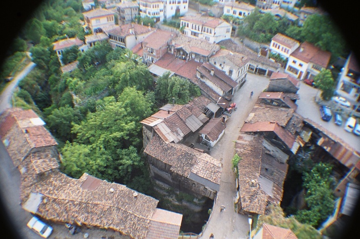
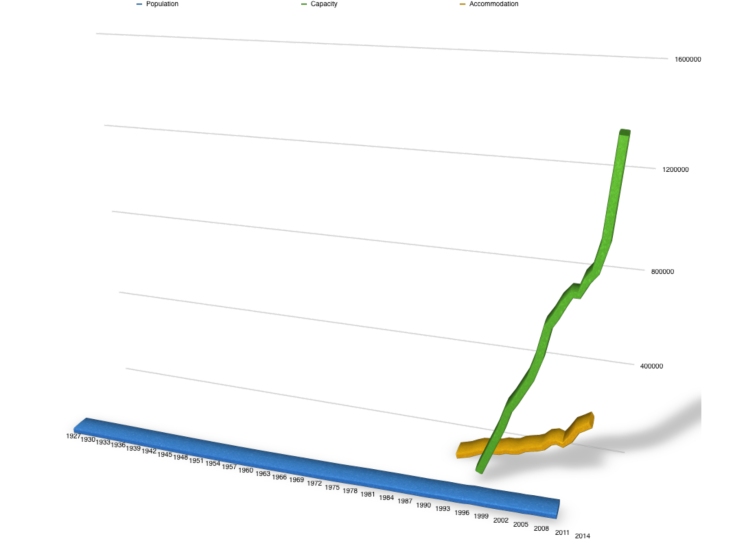 Chart: Population, Hotel Bed Capacity and Hotel Accommodation in Time
